When I first looked into buying a piece of the American Dream in Lone Star State, the sheer scale of the landscape was both breathtaking and paralyzing. Coming from regions where every square inch of property is tightly micro-managed by dense urban municipal blocks, looking at an open plot of acreage outside of Austin felt like staring at an infinite blank canvas. However, I quickly realized that the legendary phrase “Texas has no zoning” is one of the most misunderstood and potentially expensive myths in modern real estate. While it’s true that Texas champions private property rights and lacks a sweeping statewide zoning code, the reality on the ground is a complex patchwork of county regulations, deed restrictions, and environmental constraints.
For beginner investors stepping into the market, navigating this terrain manually used to take months of surveying and legal review. But the landscape has completely shifted. By integrating advanced AI terrain analysis and pulling automated county data, you can now evaluate Texas land for sale with the precision of a seasoned institutional developer right from your laptop. Whether you want to buy land for long-term appreciation, a homestead, or commercial development, this guide will show you how data-driven real estate strategies can protect your capital and maximize your returns.
1. Demystifying the Texas Land Market: Freedom vs. Hidden Restrictions
Many first-time buyers looking into Texas land investment assume that purchasing acreage in an unincorporated area gives them the absolute freedom to build anything from a dirt-bike track to a commercial warehouse. This misconception is exactly how beautiful listing photos turn into unbuildable tax liabilities. While Texas counties do not have traditional zoning authority like major cities do, they wield massive control through infrastructure requirements, platting processes, and environmental safety rules.
The Power of the ETJ (Extraterritorial Jurisdiction)
Even if your target property lies outside official city limits, it may fall within a city’s Extraterritorial Jurisdiction (ETJ). An ETJ is a geographic buffer zone extending past municipal borders where the city can enforce subdivision regulations, lot sizes, and utility extension rules. If you buy a parcel of 텍사스 땅 매매 inside an ETJ planning to split it into tiny half-acre lots, you might find the city blocking your project unless you connect to expensive municipal sewage lines.
Deed Restrictions and HOAs
In Texas, private contracts often supersede local government freedom. Deed restrictions—rules written into the property title by past owners—can permanently ban everything from mobile homes and commercial usage to specific livestock. Before making an offer on any land tract, performing a deep digital title search to extract these covenants is absolutely mandatory.
2. Revolutionizing Site Selection with AI Terrain Analysis
Historically, evaluating a massive plot of raw Texas dirt required hiring expensive civil engineers to perform physical land surveys, topography mapping, and soil core testing. If the dirt turned out to be unstable heavy clay or prone to flash flooding, you were out thousands of dollars in due diligence fees. Today, AI terrain analysis tools have turned this multi-week ordeal into an instant, highly accurate preliminary screening process.
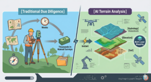
Digital Elevation and Hydrology Modeling
Texas weather is famous for its intense, localized downpours. A dry creek bed in July can turn into a raging, destructive river during spring storms. Advanced artificial intelligence platforms leverage LiDAR (Light Detection and Ranging) and satellite datasets to build highly accurate digital elevation models (DEMs). These AI systems run predictive fluid-dynamics simulations to visualize exactly how water flows across a property during a 100-year flood event. By identifying these natural runoff channels early, you ensure your future homesite or building pad stays entirely on high, dry ground.
AI Drone Imagery and Vegetative Health
Modern AI platforms go beyond simple Google Maps satellite views. By processing high-resolution multispectral drone imagery, AI algorithms can automatically classify land cover, calculate the density of brush clearing required, and assess the overall health of the soil and timber. If you are looking at West Texas acreage where groundwater is scarce, AI can analyze historical geological data alongside surface vegetation patterns to help predict the feasibility and depth required to drill a successful water well.
3. Cracking the Code on County Land-Use Regulations and Utilities
When analyzing a potential Texas land investment, your financial success depends entirely on what it costs to bring infrastructure to the property. Raw land is often cheap for a reason: it lacks basic utilities. Navigating local county land-use regulations requires understanding a few critical regional elements that govern Texas real estate.
| Texas Land Region | Primary Geographic Trait | Critical Due Diligence Focus |
| Austin-Waco-Hill Country | Limestone terrain, high elevation | Deed restrictions, rocky building costs, septic feasibility |
| East Texas (Piney Woods) | Dense timber, high rainfall | Land clearing economics, floodplain boundaries |
| West Texas / Panhandle | Vast, flat, low population density | Water well depth, utility proximity, wind/solar easements |
| Gulf Coast / Metro Houston | Heavy expansive clay soils | Advanced drainage plans, engineered foundation costs |
Septic System Feasibility and Soil Testing
If the property you are evaluating is outside city limits, you will need to install an On-Site Sewage Facility (OSSF), commonly known as a septic system. Texas counties enforce strict rules regarding the type of septic system permitted based on a physical “perc” (percolation) test of the soil. Heavy clay soils common around the Houston and Dallas metros do not absorb water well, meaning a standard gravity septic system will be rejected. Instead, you will be forced to install a complex, expensive aerobic spray system, adding unexpected thousands to your site-development budget.
Water Rights and the Rule of Capture
Texas follows the legal doctrine known as the “Rule of Capture” for groundwater. In simple terms, this gives landowners the right to pump the water beneath their land. However, this is heavily moderated by local Groundwater Conservation Districts (GCDs). As industrial projects like massive AI data centers boom across Texas, local groundwater districts are tightening rules on high-volume water permits. Before purchasing land intended for agricultural use or commercial operations, you must verify the local GCD’s rules on allowable well yields and spacing.
4. Maximizing ROI: Leveraging Agricultural Exemptions and Future Growth Corridors
The carrying cost of holding raw land can quickly eat into your investment returns if your property taxes are calculated at the “highest and best use” market value. Fortunately, smart investors targeting Texas land for sale utilize the state’s generous property tax structures to minimize overhead while the land appreciates.
Securing an “Ag Exemption” (1-d-1 Open-Space Appraisal)
An Agricultural Exemption is not actually a tax exemption; rather, it is a special assessment method where the county appraises your land based on its agricultural productivity rather than its speculative market value. This can slash your annual property tax bill by up to 90% or more.
-
The 5-Year Rule: To qualify for a 1-d-1 open-space appraisal, the land must have been principally devoted to an agricultural use (such as livestock grazing, timber production, or crop farming) for five out of the preceding seven years.
-
AI for Ag Management: Modern land investors use AI automated tracking to monitor livestock patterns, document property usage, and optimize rotational grazing plans, creating a digital paper trail that easily satisfies county appraisal district audits.
Predicting Growth Corridors with Machine Learning
The ultimate secret to generating massive wealth through Texas land investment is buying property right in the path of upcoming suburban sprawl. Predictive AI platforms analyze dozens of macro-economic indicators—including historical population migration, planned highway expansions by the Texas Department of Transportation (TxDOT), corporate relocation data, and electrical grid capacity. By feeding these variables into a machine-learning model, you can identify undervalued “growth corridors” outside major metros like Austin, Dallas, and Houston, allowing you to secure affordable tracts before large-scale developers drive up market prices.
Conclusion: Building a Data-Driven Foundation for Success
Investing in Texas real estate remains one of the most lucrative wealth-building strategies available today, but the old-school days of buying raw land based purely on a “good gut feeling” are long gone. The independent nature of the state means that responsibility for due diligence falls squarely on the buyer’s shoulders.
By combining the speed of AI terrain analysis to check topography and flood risks with a disciplined, meticulous review of county land-use regulations, you can effectively eliminate the guesswork from land accumulation. Do your digital homework, verify your utility access, protect your tax status with smart agricultural planning, and you will turn the vast, open Texas landscape into a highly predictable, highly profitable investment portfolio.
Technical Glossary for First-Time Buyers
-
ETJ (Extraterritorial Jurisdiction): Unincorporated land outside a city’s legal boundaries over which the municipality still retains limited regulatory and subdivision development control.
-
LiDAR Mapping: A remote sensing technology that utilizes laser pulses to generate highly accurate, 3D topographical profiles of land surfaces, cutting through thick vegetation to reveal true ground elevation.
-
Deed Restrictions: Private, legally binding restrictive covenants embedded within a property’s title deed that dictate how the land can or cannot be used, completely separate from local government laws.
-
Rule of Capture: The Texas common-law doctrine stating that landowners have a legal right to pump and utilize the groundwater directly beneath their surface property without liability to neighboring landowners.